Trig Spatial Information
Reliability, Innovation and Professionalism
Trig Spatial Information
Reliability, Innovation and Professionalism
Trig Spatial Information
Reliability, Innovation and Professionalism
Trig Spatial Information
Reliability, Innovation and Professionalism
Trig Spatial Information
Reliability, Innovation and Professionalism

Trig Spatial Information – Reliability, Innovation and Professionalism

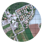
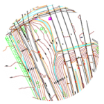
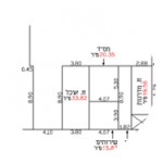
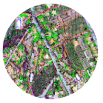
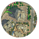
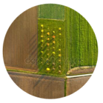
Trig Spatial Information has been active in the various geo-information fields for the past 15 years, from aerial photography in various scales, aerial mapping, land mapping, orthophotographs, bathymetries, measurements for city property tax purposes, and various diversified surveys, to 3D modeling and combinations of aerial, maritime and land measurements.

Trig’s human capital, extensive accumulated knowledge and state-of-the-art technologies have allowed it to promote engineering projects for its diverse client base.

Trig is led by Irit Pinkas, who has accumulated extensive experience and reputation throughout her career.

The staff includes only the best Aerial Mapping and Spatial Information professionals.

The company offices are located in Kibbutz Horshim, Israel.

| Would you like to join our client base? You’re more than welcome to contact us!

| Services

Aerial Photography

Aerial photographs are the basis of aerial mapping, orthophotography and 3D modeling, which are used to generate topographic…
| read more »

Orthophotography

Vertical aligned aerial orthophotography enables observation of visual information that is used by a variety of professionals and industries…
| read more »

Aerial Mapping – Photogrammetry

Aerial mapping/photogrammetry is the basis of any engineering, nfrastructural and planning work.
| read more »

Field and GPS Measurements

We employ specialist measurement teams equipped with innovative GPS devices and other equipment to perform measurements…
| read more »

City Property Tax Measurements

Trig Spatial Information has been operating for years in the fields of city property tax measurements and supervision of construction…
| read more »

Geographic Information Systems (G.I.S)

The establishment and organization of vector and Raster databases for our clients, also supported by geographic information systems…
| read more »

Maritime Mapping

Expert services of aerial photography analysis and court statements. If needed, the expert will attend the court to submit their testimony.
| read more »

Surveys

Available, reliable and accurate geographic knowledge is the core of any engineering planning work, and also of proper…
| read more »

Aerial Photography Analysis

Expert services of aerial photography analysis and court statements. If needed, the expert will attend the court to submit their testimony.
| read more »

3D Modeling

3D modeling allows for advanced planning and engineering capabilities, based on a cloud of points generated with smart photo…
| read more »